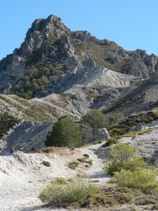
Although by no means one of the highest mountains in the Sierra Nevada, the striking peak of Trevenque is recognised as a tough climb due to the rugged and steep final ascent. At the summit you will be rewarded with 360° views of Veleta, the Sierra Nevada ski station, and surrounding mountain ranges including the Sierras de Alhama, Tejeda y Almijara, Sierra de Huétor and Sierra Elvira. It’s no wonder that Trevenque is known locally as the “King”. The walk returns through the beautiful river Dílar valley.

Level As already noted, the steep final ascent makes this a tough walk. Added to this, Trevenque’s terrain is quite difficult, with a loose surface of gravel and sand that makes the going harder. A walking pole is recommended for the slippery descent. The route uses a mixture of marked trails and unmarked paths, and some care is needed with navigation over the middle section.
When to go The walk is possible at any time of year, but spring and autumn are most recommended. There is little shade to protect you from the heat, so it is essential to start out early in summer, and in severe winter weather the most difficult sections could be treacherous.
Water Make sure you carry enough water for the ascent, as there is none available until you get to a spring on the homeward leg.

Location: NW Sierra Nevada, Fuente del Hervidero
The route starts near Fuente del Hervidero, a traditional country restaurant on the edge of the Sierra Nevada Natural Park, accessed from La Zubia. You can either start at the restaurant or at another car park beside the trailhead – see transport section below for more details.
Transport

By Car: From Granada, take the La Zubia exit from the southern ring road (Ronda Sur). When you reach La Zubia go straight on at the traffic lights then take a left signposted to Cumbres Verdes (you cannot turn left directly, so continue up to the roundabout, do a u-turn and then turn right). Then follow signs to Cumbres Verdes. You soon enter the Sierra Nevada Natural Park, and, after a few kilometres, pass Cumbres Verdes on your right. The road then turns into a dirt track. Follow this for 1.5km until you reach Fuente del Hervidero (turn off left). Either park here or carry on 1km to another car park at the trailhead, but bear in mind that this stretch of road is often in poor condition.
By bus: There is no bus service to Fuente del Hervidero. On weekends there are two buses a day to Cumbres Verdes (service 275), from where you need to walk 1.5km up a dirt road to Fuente del Hervidero. Click here for more details and a link to current bus timetables.

