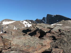
On a clear day, the peak of Veleta offers 360° views of the surrounding mountains of the Sierra Nevada, the city of Granada, the Mediterranean and even Africa. In summer and early autumn the ascent is remarkably straightforward for being such a high mountain, and the fresh mountain air at the summit is a welcome relief from the heat at lower altitudes.
Level By taking a bus or ski lift (see Transport), you can save yourself a lot of climbing, and start walking at an altitude of over 3,000 m, within striking distance of the summit, which makes the walk suitable for most people. The times and distances quoted assume you do this, but we include the full route from Hoya de la Mora, just above the ski station, for completeness (see the downloadable information sheet for more details). While there is some satisfaction to be gained from tackling the full walk, it is very long, and the lower section isn’t where the best views are to be found.
The route is easy to follow and the terrain is undemanding, although if you prefer you can take slightly more challenging short-cut paths.
One thing to bear in mind is that although the walk is basically fairly straightforward, there is a small risk that you will suffer altitude sickness, in which case you will need to head back down.

When to go Best in the summer months or early autumn, when there is little risk of snow causing you problems, although as you can see from the photos, there can be patches of snow even in midsummer.
Location: NW Sierra Nevada, Pradollano
The walk starts from above the Sierra Nevada ski station at Pradollano
By car: From Granada take the A-395 marked to Sierra Nevada. Either park at the ski station and take the cable car and chairlift, or turn off left just before the ski station (signposted Parking de los Peñones) and follow the road up until you get to Hoya de la Mora at the end of the main road at an altitude of about 2500 m. Beyond this point, only authorised vehicles are allowed. From here, you can catch the National Park’s microbus service, see below.
By bus: from Granada bus station (1 bus per day). Click here for more information and links to current timetables.
Microbus: The National Parks office runs a microbus from Hoya de la Mora to Posiciones del Veleta. Click here for more information.
Ski lifts: During July and August, the ski station runs a summer lift service using a cable car and one of the chairlifts. More information on the ski station website (during the summer season only).

